

Zdjęcia na folii samoprzylepnej autora Peter Hermes Furian
FILTRUJ WYNIKI
Orientacja obrazów: wszystkie
pozioma
pionowa
kwadratowa
Rodzaj obrazów: wszystkie
zdjęcie
ilustracja
wektor
Zastosuj
#813718153
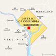 Washington, D.C., political map. District of Columbia, capital city and federal district of the...
#811718221
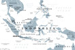
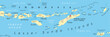 Lesser Sunda Islands, Indonesia, political map. Nusa Tenggara Islands, archipelago Southeast Asia....
#806892639
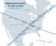 Great American Eclipses, Paths of Totality, political map. Total Solar Eclipses of August 21, 2017,...
#806352184
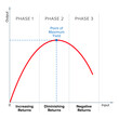 Law of diminishing returns. E.g. if you continually increase the amount of work on a constant arable...
#805968326
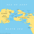 Kerch Strait in Eastern Europe, political map. It connects the Black Sea and Sea of Azov, separating...
#805489681
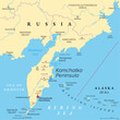 Kamchatka Peninsula, and the federal subject Kamchatka Krai of Russia, political map. Peninsula with...
#805489669
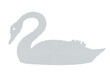 Dotted black swan symbol, silhouette of a swan made of circularly arranged gray dots. Symbol for a...
#805066233
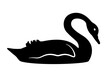 Black swan, outline and silhouette of a large waterbird. A symbol for black swan events and theory,...
#804962861
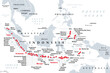 Major volcanoes in Indonesia, political map. Southeast Asian country dominated by volcanoes, formed...
#804962820
 Celtic knotwork, circle frame with a decorative loop border, a pattern in typical Celtic style....
#803102889
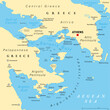 Argo-Saronic Gulf, Saronic and Argolic Gulf of Greece, political map. The peninsulas of Attica and...
#802320434
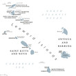
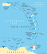 Eastern Caribbean islands, political map. Puerto Rico, Virgin Islands, Leeward and Windward Islands,...
#802320369
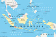
 Indonesia, a country in Southeast Asia and Oceania, gray political map. Republic and archipelago...
#802320277
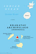 Krakatau Archipelago, Indonesia, political map. Four uninhabeted, small volcanic islands, formed by...
#802320230
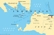 Sunda Strait, Indonesia, political map. Strait between the Indonesian islands Java and Sumatra,...
#800466733
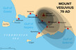 Eruption of Mount Vesuvius in 79 AD, history map. General distribution of ash and pumice. Major...
#800466664
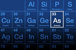 Arsenic element on the periodic table with element symbol As and with the atomic number 33. Its...
#800466575
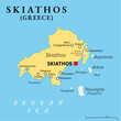 Skiathos, small Greek island, political map. Island in the Aegean Sea, part of the Sporades, with...
#800466422
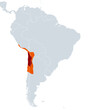 Atacama Desert, political map. Hyperarid desert plateau, located on the Pacific coast of South...
#799763973
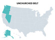 Unchurched Belt, a region in the northwest of the United States, political map. Region with lowest...
#798809742
 From Anguilla to Montserrat, gray political map. Caribbean islands, part of Leeward Islands and...
#798809707
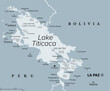 Lake Titicaca, gray political map. Large freshwater lake in the Andes mountains on the border of...
#798809597
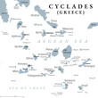 Cyclades, group of Greek islands in the Aegean Sea, gray political map. Southeast of mainland...
#798809508
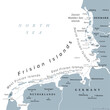 Frisian Islands, gray political map. Wadden Sea Islands, archipelago at North Sea in Europe,...
#798191322
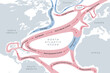 Map of the Gulf Stream and major North Atlantic Ocean currents. Sea water is circulating in...
#798161113
 Indonesia, a country in Southeast Asia and Oceania, political map. Republic and archipelago with...
#793877704
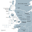 Nordfriesland, or North Frisia, gray political map. Northernmost district of Germany, part of...
#793877649
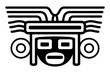 Head with mask large headdress, an ancient Mexican motif. Pre-Columbian, Aztec flat clay stamp...
#792777447
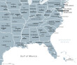 Southeast Region, South of the United States, gray political map. Geographic and cultural region,...
#792777395
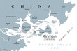 Kinmen, also known as Quemoy, gray political map. Group of islands governed as county by Taiwan, the...
#792425591
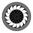 Radiating feathers, 16 feathers rotating around a center, framed by circles. Probably the symbol for...
#795271454
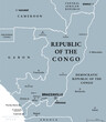 Republic of the Congo, gray political map. Also known as the Congo, a country located on the western...
dodaj do ulubionych